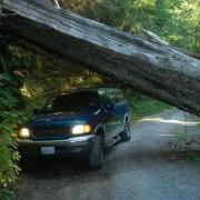
McCulloch Peak is another great peak to actiavte if you are in the Corvallis area. It is reached by taking OR Hwy 99W north from Corvallis and turning left about 3 miles from town on Lewisburg Rd. Take Lewisburg road 1.3 miles and bear right onto Sulfur Springs Road. Proceed to the top of Lewisburg Saddle and head back down the hill. Near the bottom of the hill, which is Soap Creek valley, the road will take a 180 degree right turn. This point is 3.9 miles from Hwy99. Stay straight turning onto the gravel road.
Activation Reports
Current trail conditions are packed snow and ice. Probably more to come in the next couple of days. We didn't bring our Yaktrax and paid the price by slipping and sliding all over the place. Our ascent took too long, and the more careful descent even longer.
This is a continuation of a trip I took to W7O/CM-132 during which I also
went to Sand Mountain, W7O/CM-077. Proceed as mentioned in the other blog
entry for W7O/CM-132, but before reaching the Big Lake Campgrounds turn
off FS 2690 onto FS 810, the Old Santiam Wagon Road. Road 810 is open to
mountain-bikes and apparently from the signage is also an active OHV area.
Take road 810 about 3 miles (estimated) until a road leads off to the left
marked with a sign denoting the Sand Mountain Special Geological area. Take
There is a small peak south of Big Lake and the Hoodoo Butte ski area that
has piqued my interest for some time. (Ah, bad pun) I was there during a warm
day in March. However, Big Lake road is closed beyond the Ray Benson snopark
until May. Therefore, I took my mountain bike and figured I could cover the
road mileage quickly and also ride over to Sand Mountain and get both peaks in
the same day.
Big Lake road is also National Forrest road NF 2090. It intersects US HWY 20
roughly at Santiam pass. Take Big Lake road past the entrance to Hoodoo Ski
The summit near "Dimple Hill" (W7O/CC-118) in McDonald forest near Corvallis
is a nice first summit or a good summit if you are in the area but don't have
much time to spare. To get there, travel north about 4 miles on OR 99W from
Corvallis until Lewisburg Road crosses 99w at the "City Limits Store". Turn
left on Lewisburg Road and travel 1.3 miles where Sulfur Springs Road heads
off to the right. Take Sulfur Springs road for 1.5 miles to the Lewisburg
Saddle (at the top of the grade) where there is ample parking for the trailheads
K7MK and I headed out to activate this summit as our first ever activation. K7MK has been assembling a SOTA capable station for the last 6 months or so. We have done a dry run or two in his back yard and even hauled it up to a non-SOTA summit back in February on a rare warm winter weekend afternoon. But, this was our first real activation.
If you are headed from Portland to Lincoln City, this could be your activation on the way. Or the way back. It's a drive up on a decent dirt and gravel road with the potential for a nice view at the top.
A successful day on Jester Mountain! Made the minimum required 4 contacts on 146.52-FM, then made a hasty retreat down to escpae the blowing snow and cool temperatures. A great day to be outside after not be able to hike last weekend. Trail to Iron Bear is snow-free; descending the saddle to Jester Mountain there was only trivial amounts of snow. I used my Yaesu VX-6R coupled to an MFJ-1714 1/2 wave dipole. Had great signal into both Wenatchee and Cle Elum.
The Pack Forest is operated by the University of Washington, a bit south of Eatonville, Washington. www.packforest.org. Pack Forest High Point is not particularly well marked on the trail map and you may find that signage is a bit confusing, but it's a nice hike on a good forest road - about six miles round trip and 1100 feet elevation gain.
Red Hill (KH6/MA-001) is the tallest peak of Haleakala (“House of the Sun”) located in Haleakala National Park on the island of Maui in Hawaii. It is commonly called Haleakala even though Red Hill is the actual name of the summit. Red Hill is a drive-up, and a drive-up only. Visitors are not permitted to walk the extra 283 vertical feet on the paved road from the Haleakala Visitor Center at 9740ft / 2969m to the summit at 10,023ft / 3,055m. There is no shoulder on the road. There is also no trail to the summit, and walking off-trail is also not allowed.