I never thought that at the end of January we would have mosquitoes, but there they were all over me at the top of David Hill. If that’s not a reason to go activate the summit, then what about this view on the way to the top?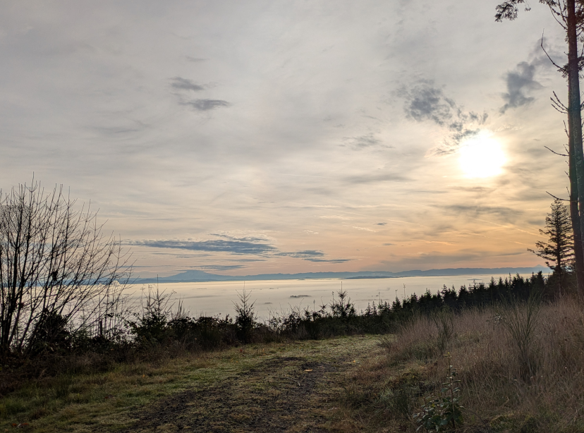
Activation Reports
Submitted by KJ7QYK on
Summit:

Submitted by K7WXW on
Summit:
Summary - If the gate is locked (and it probably is), this is a two mile logging road hike and summit hill bushwhack with modest elevation gain. On a clear day there are views from the north end of the summit. The bushwhack is relatively short with a few sections of thick brush. Round trip hike is under five miles with almost 1000 feet of elevation gain. Spotting with APRS or ATT cell service is possible. Bring HF gear as 2M contacts may be a chore. The hike and summit are on Hood River County Forest land with active logging sites.

Submitted by W6PZA on
Summit:
Heads up… on Jan 10, 2026 when driving from W7O/NC-091 to NC-083 (as noted in the prior descriptions) I came across a slide located along the southeast side of the mountain - very close to the final turn up to the NC-083 summit. I had to backtrack and take the logging road that wraps around the north side of summit. Not sure how long this route will remain blocked, but it may be a low priority to clear.

Submitted by WU7H on
Summit:
DJ (WW7D) and I (WU7H) saved this one for our 2025/2026 UTC rollover activation. We have done Keechelus in the winter before and it is usually a very reliable winter summit -- there is a groomed snowmobile trail that gets you close enough to the summit to snowshoe up. We attempted to do this as a UTC rollover back in 2019 but it was raining heavily (even at 5000') and we were so wet, cold, and miserable we bailed before the UTC rollover. This year we got lucky - it was a bluebird day!

Submitted by KR7Q on
Summit:
This is an easy drive up summit with beautuful views of the Bitterroot Valley seen on part of the road accessing the summit.
Direction to WM/GA-114:
From Missoula, MT take US-93 South Approximately 20 Miles to Florence.
Turn East on Eastside Highway SR-203 for 7 miles to Ambrose Creek road.
Turn East on Ambrose Creek Road for 5.4 miles to FS 428. Take FS428 7.8 miles to Ambrose Saddle.
At Ambrose Saddle take FS1339 SE approximately 6 miles to the intersection of 1339 A and 1339B

Submitted by K7VK on
Summit:
Summit #7845 is a good hike through the 2021 Trail Creek wildland fire. The trail signed Ruby-May Creek #3102 was in great shape and being cleared by a Montana Conservation Corps crew during the activation. There are some good views of the Anaconda-Pintler Wilderness summits along the trail.
Caution: this trail and the summit have elevated snag hazard due to recent wildland fires.
Submitted by K7VK on
Summit:
Shook Mountain is the apex on the north end of a small rib of mountains lying between the East and West Forks of the Bitterroot River, and the Idaho/Montana border to the south. Having good views of both those valleys there are also fine views of rugged peaks in the Selway-Bitterroot Wilderness.
Submitted by K7VK on
Summit:
White Mountain, a US Forest Service Lookout since 1934, had been updated to an L4 Lookout cabin on a 41’ wooden tower in 1954. It is on the National Register of Historic Lookouts. It has good views of the southern Bitterroot Mountains, the Great Burn Wilderness Study Area, the Idaho/Montana border and the Lolo National Forest.
Current access is hiking approximately 2 miles through forest and along a permanently closed road.
Submitted by KR7Q on
Summit:
Directions to Slide Rock Mountain W7M/GA-093:
From Missoula, MT 24.6 miles on I-90 East to Exit 126 (about 17 Miles)
South on Rock Creek Road for approximately 9 Miles
Turn East on Brewster Creek Road ,
Follow for 7 miles to County Road 354,
Follow for 2.6 miles to Slide Rock Mountain W7M/GA-093
Submitted by K7VK on
Summit:
This summit is slightly prominent over the old Ninemile Lookout Site. A sign on the summit points to this old lookout site approximately 0.25 miles east. Elevation difference is 28’. All that remains of the lookout are four large concrete support blocks, burned wood and rusting hardware scattered on the ground. Slow growing subalpine fir tower to over 40’ on the site.
The remainer of the summit is dense old forest with oddly shaped rock outcrops of banded-argillite. Due to dense forest, there are very limited vistas of the valleys below.